Historiography of Sirinićka župa
The Kosovo basin is a very significant physical unit. Its vast wavy fields are brilliantly meandered by calm-flowing rivers. The Kosovo region is framed by high mountains: Šar Mountain and Prokletije, whose ridges are sharp peaks and jagged like the Alps. On the edge of the Kosovo basin rises Šar Mountain, often glorified in Serbian folk songs. On it, Miloš Vojinović, the nephew of Emperor Dušan, grazed his flocks. According to folk tradition, Prince Marko sleeps in it, who will awaken when the Serbian empire is resurrected. Every peasant in this area knows about these remnants of the old Serbian state and these folk traditions.
Šar župas Sirinić and Sredska extend between Prizren and Kosovo. In these župas, the customs of the Serbian people and folk costumes have been preserved.
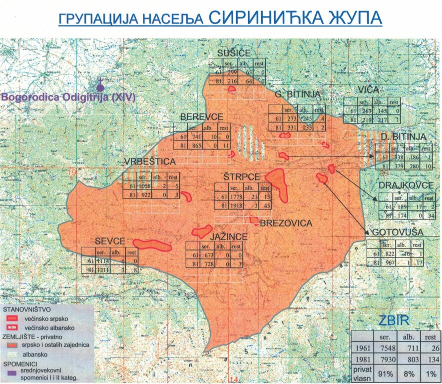
In the northern slopes of Šar Mountain, between its sharp ridges and Prevalac, Ošljak, and Jezeračka Mountain, lies the elongated Lepenac basin, long known as Sirinićka župa. This narrow winding river valley, surrounded on all sides by high and almost inaccessible mountains, far from main traffic routes and communications, remained cut off from surrounding urban centers for a long time. Until the forties of the 20th century, the only traffic connection of Sirinić with the surroundings was a narrow village road, which connected the župa with Uroševac, i.e., Kosovo through the Brod Gorge. Within the borders of Sirinićka župa there are fifteen villages: Sevce, Jažnice, Štrpce, Gotovuša, Drajkovac, Firaja, Brod, Vrbještica, Berevce, Donja Bitinja, Sušiće, Koštejevo, Viča and Ižance. Thanks to its peripheral position, despite war destructions, several very interesting churches from the 16th century have been preserved in these villages.
At the end of the last century, Petar Kostić, a professor at the Prizren Theological Seminary, passed through Sirinićka župa and published his observations within the study of the history of Prizren and its surroundings thirty years later. Of all previous researchers, he provided the most comprehensive overview of churches in this župa: in Štrpce - churches of St. Nicholas and St. John, in Berevce - St. Petka, in Gornja Bitinja - St. George, in Donja Bitinja - St. Dimitrije and St. Teodor Tiron, in Gotovuša - St. Virgin Mary and St. Nicholas, in Drajkovac - Holy Forty Martyrs, in Viča - St. Dimitrije, and in Brod - St. Peter.
After being abolished on December 31, 1965, the Assembly of the Municipality of Štrpce was reformed on August 10, 1988. The municipality covers an area of 247.36 km² in the northeastern region of Šar Mountain, in the upper part of the Lepenac river basin, also called Sirinićka župa. The municipality currently has about 13,600 inhabitants in 16 settlements.
The Municipality of Štrpce represents the southernmost Serbian enclave in Kosovo and Metohija. Sirinićka župa is a hilly-mountainous area with a specific rugged entity and an altitude range that ranges from 900 meters in the Lepenac valley to 2500 meters at the top of Ljuboten. The territory of the Municipality of Štrpce has a relatively favorable position in relation to the urban, administrative and economic centers of Kosovo and Metohija, as well as the northern and northwestern parts of Macedonia. In the immediate vicinity are the municipalities of Uroševac, Kačanik, Suva Reka, and Prizren.

In the composition of the Serbian medieval state, Sirinićka župa entered at the beginning of the 13th century, during the time of Stefan Prvovenčani. The first, oldest mention of Sirinićka župa discovered so far is found in a gospel from the 13th century written on parchment, which is now kept in the National Library in Paris. Another mention of Sirinić dates from 1331, in the text of the Charter of King Stefan Dušan, given to the tower of the Hilandar Monastery, from which it is seen that Sirinićka župa was earlier a metoch of the Hilandar Monastery. Ottoman censuses from the 16th century show that at that time there were no Albanian settlements in this župa, but all were Serbian.
Sirinićka župa survived under Turkish occupation and in all major wars, but the consequences are visible in the demographic structure. The municipality currently has about 13,600 inhabitants, of which 9,100 are Serbs, 4500 Albanians, and 30 Roma, with a small average population density of about 60 inhabitants per square kilometer, which is characteristic of hilly-mountainous areas. The basic demographic features are slow growth in the total number of inhabitants and a mixed national composition. The territorial distribution of the population is extremely unbalanced.
The municipality has about 900 internally displaced persons of Serbian nationality, of which about 400 live in collective centers, and the rest reside in private houses.
Of the total of 16 settlements in the municipality, half are inhabited by Serbs, these are Štrpce, Brezovica, Vrbještica, Jažnice, Berevce, Gotovuša, Sevce, and Sušiće, a quarter by Albanians: Brod, Firija, Ižance, and Koštejevo, and the remaining four settlements, Viča, Drajkovce, Gornja and Donja Bitinja, have a mixed national composition.
In this region, they still consistently practice and thus preserve their customs related to weddings, Đurđevdan, Christmas, White Sunday before Easter, and the holiday of Easter itself. The help of the Veljković family from Gotovuša was precious, and our stay in this area was an occasion for the gathering of young people in the cultural and artistic society 'Mladost,' which continued to nurture songs and dances from Župa and its surroundings. The singing group, which included Dragan Stojanović, Radojko Stojković, Tihomir Stevanović, Ljubiša Milijić, and Veselin Milatović and Slaviša Dobrosavljević from Brezovica, won the award 'Čuvari Baštine' in the RTS show 'Šljivik' in 2013.